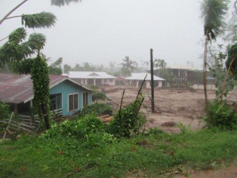
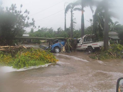
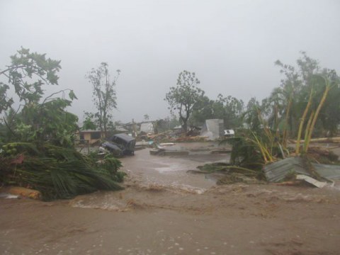
The tropical paradise of Samoa in the South Pacific has been lashed with gale force winds, flash flooding from torrential rain and a 3 metre storm surge from Category 2 tropical cyclone Evan on Thursday and Friday. After two days the tropical cyclone is now moving west and intensifying to a Catergory 4 storm as it heads in the direction of Fiji. Wallis and Fortuna Islands lie directly in the storm path and northern atolls of Tonga may also be affected to some degree.
On Samoa, three people have been confirmed dead with seven people missing. Large parts of the capital Apia is flooded, and the airport and port are closed. The Vaisigano River which runs through the middle of Apia burst it's banks causing widespread flooding. Uprooted trees have brought down power lines in many areas with electricity grid disrupted for most of Samoa. While power is expected to be restored to Apia's Central Business District by Saturday, it may be several weeks before electricity is restored to outlying villages. A water treatment plant has also been destroyed reports the Sydney Morning Herald.
The storm is the most powerful in the region for 20 years, and one of the most destructive in Samoan Cyclone History. Read a first hand report in the Samoa Observer: Shock as Cyclone Evan belts Samoa. See photos: Samoa Reels from Cyclone Evan
On Thursday afternoon Samoan Deputy Prime Minister and Acting Chairman of the National Disaster Council, Fonotoe Pierre Lauofo, made a "declaration of disaster" on the national radio. As of Saturday a massive cleanup has started to restore power and rebuild after the destruction wrought by the cyclone.
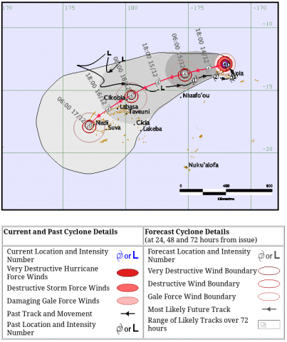
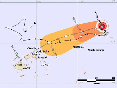
Caption: Projected path of Tropical Cyclone Evan early on December 14. More recent projections show the forecast track proceeding slightly to the north, to hit the northern islands of Fiji on Sunday afternoon.
Evan is the first named cyclone of the South Pacific's summer cyclone season this year. Evan grew from a tropical storm into a categorised cyclone between December 11 to December 13, with maximum sustained winds had increasing to 90 knots (103 mph/166.7 kph) according to NASA.
The cyclone arrived at Samoa on Thursday morning, December 13, with little warning pounding the islands. Thousands of people were forced to evacuate their homes and villages to evacuation centres, usually church halls.
According to a report, the cyclone was still near Samoa's Upohu island on Friday causing waves of up to 6 metres.
Fiji Prime Minister warns of Threat
The cyclone is continuing to intensify and is likely to become a category 4 storm and could potentially reach category 5 (the highest storm ranking). The tropical cyclone is projected to hit Tokelau to the north of Samoa, then the Wallis and Futuna Islands, before hitting Fiji and possibly Vanuatu. Later in the week Evan might even impact the north Island of New Zealand as it works it's way around a blocking High.
Fiji Priime Minister Voreqe Bainimarama has addressed the Nation to be on alert. Evan is expected to directly hit Fiji on Sunday. The Prime Minister warned people to secure property and stock up with food and water in preparation for the Tropical cyclone to hit Fiji. (Watch the address on youtube)
At 4pm on Friday 14th December the Fiji Meteorological Service issued a strong warning in a media release to residents of Tonga and Fiji to prepare for damaging winds, flooding and storm surge.
The cyclone is intensifying and expected to attain Cat 4 status in the next 12 to 24 hours. As it exists under very favourable oceanic and atmospheric conditions, there is a good probability of it attaining CAT 5.
At this stage, and on its projected track as well as intensity trend, TC Evan should move across the northern parts of Tonga on Saturday and arrive into the Fiji waters later on Sunday 16th December, as a CAT 4 or possibly CAT 5, severe tropical cyclone.
Damaging heavy easterly waves/swells will precede the cyclone, generated by the combined effect of TC Evan and an intense area of high pressure to the far south of Fiji. The resultant wave attack on our coastal communities, especially those facing the east and northeast, as well as those near the path of the cyclone, is expected to be severe. At this time, maximum sustained winds near the centre of the cyclone, as it moves into Fiji, are anticipated to be around or above 180 km/hr. Associated momentary gusts will be a lot higher, at the most, double these values. Rain
will be frequent and heavy. Flooding including sea flooding of coastal areas is expected.All communities in Fiji should be prepared now, heed warnings, and act responsibly, to avoid unnecessary loss of lives and/or property.
You can follow updates on the Fiji Meteorological Service Facebook Page - following here reduces the demand on their own website.
South Pacific and climate change
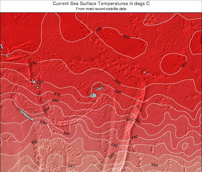
Elevated sea surface temperatures assist cyclones intensifying. Dr Jeff Masters of the Weather Underground forecast that "The storm will be a region with light wind shear of 10 - 15 knots and very warm ocean waters that extend to great depth, and could intensify into a Category 4 cyclone by Saturday, as it passes through the Wallis and Futuna Islands." Evan is expected now to pass just north of Fiji.
The map below from Surf-forecast.com shows the elevated sea surface temperatures in the area between Fiji and Samoa. We also know that a warmer atmosphere carries more water increasing torrential rainfall and flooding.
Like with Hurricane Sandy, Typhoon Bopha there is a component of systematic climate change built into extreme weather events now. The IPCC released a report on Extreme weather, risk management and adaptation in a warming climate in November 2011. In January and February 2012 Fiji's climate disaster preparedness was tested with major flooding in western areas of Fiji.
According to an international study led by CSIRO oceanographer Dr Wenju Cai global warming is causing shifts in the rain band of the South Pacific Convergence Zone causing an increase in extreme weather across the island nation states of the South Pacific. The result of the movement causes drought and higher prevalence of forest fire in some areas while other islands experience extreme floods and increased frequency of tropical cyclones.
A report released in November 2011 on climate change in the Pacific Ocean region said that the region is getter hotter, sea levels are rising, rainfall is changing and equatorial winds have weakened. While cyclone may tend to decrease slightly in the future, cyclone intensity is likely to be greater.
Extreme weather events like severe Tropical Cyclone Evan provide the necessity for climate adaptation finance under the UNFCC process to help small island and developing countries like Samoa and Fiji to adapt and prepare for climate disruption events. Equally important is use of such funding and expertise from developed nations in rebuilding to take account of the increasing intensity of such events in the future.
Sources:
- Projected track for Severe Tropical Cyclone Evan from RSMC Nadi Tropical Cyclone Warning Centre, Tropical Cyclone Warning Number 30 issued 1000 UTC Friday 14 December 2012
- Fiji Meteorological Service, Media release 4pm December 14, 2012 - Severe Tropical Cyclone "Evan"
- Lead image of flooding and torrential rain in Samoa taken on December 13 from Savalinews.com : Samoa Reels from Cyclone Evan. Visit to see more photos
