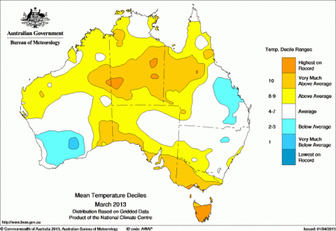
Tasmania, that small island state of Australia that protrudes into the Southern Ocean, has recorded it's hottest March on record in over 100 years of temperature record keeping.
The mean March temperature across the state was 15.7C, breaking the 1974 record by 0.3 degrees and 2.2 °C above normal. The Bureau of Meteorology said in a statement "The state average maximum temperature was a March record of 21.0 (2.9 °C above normal and 0.9 °C above the previous record from 1974), and minimum temperatures were the 3rd-warmest for March at 10.3 °C (1.6 °C above normal)."
The hottest day was at Bushy Park where the temperature rose to 37.4C. Several sites, including Launceston, recorded their highest March temperature on record.
The warmest recorded night in the state was at Burnie on March 12 with 21.2 C. Hobart, Bicheno and Devonport, and several other sites recorded their warmest March night on record.
High Rainfall records for March were also broken at Barrington and Westbury.
Australia experiences hottest September to March on record
The state suffered a persistent Autumn heatwave from March 2 to 13 along with Melbourne and much of south eastern Australia. Indeed, Peter Hannam in the Sydney Morning Herald reports much warmer conditions were experienced over much of Australia, with the exception of the South region of Western Australia that had a relatively cool March:
- Average maximums across the country for March alone came in at 32.67 degrees, or 1.25 degrees higher than the long-term average set for the 1961-90 period, and just behind the record set in 1998.
- Melbourne sweltered through it's third hottest March on record with the average maximum of 27.6 degrees was 3.7 degrees hotter than normal.
- Sydney's March was above the norm with an average of 26.4 degrees - the city's seventh hottest. No day had less than 20 degrees and in 22 of them the mercury climbed to 25 degrees or warmer.
- Averaged over Australia, the September-March period was the hottest in more than a century of data collection.
- Late season maximum temperature records were broken with 45 degrees exceeded later this year than in any previous one. Victoria also beat its late-season record with a 38.8 degrees at Swan Hill, while Birdsville in Queensland (42.9°C) and Fowlers Gap in NSW (40.9°C) also set similar late-season records for their states on March 27.
Ian Barnes-Keoghan from the Bureau of Meteorology described how the warm weather occurred, "From about the 2nd to the 13th, there was a high pressure system sitting over the Tasman Sea that persistently brought warm air down over south-east Australia, and on to Tasmania," he said. "What we saw across that south-east was a persistent heatwave, temperatures just didn't cool down." according to an ABC news report.
According to the Bureau of Meteorology, the early March extended heatwave was caused by:
"A near-stationary high over the Tasman Sea directed warm air across the state from the 2nd to the 13th, and coincided with exceptionally high sea surface temperatures. The heatwave was characterised by prolonged sequences of days and nights above threshold temperatures, and was accompanied by high humidity and generally light winds. Launceston reached 30 °C on 8 consecutive days from the 5th to the 12th, double the previous record for such a warm spell (28 to 31 January 2009). Lake St Clair and Sheffield both had an unprecedented 9 consecutive days reaching 25 °C, whilst Hobart Airport and Orford had 7 consecutive nights above 15 °C."
Exceptionally high sea surface temperatures sign of Ocean Warming
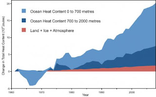
You may have heard it said that there has been little rise in surface temperatures for the last 15-16 years. This is accurate if you cherry pick the starting date: 1998, an extremely hot El Nino year. But it also ignores that up to 90% of warming goes into the ocean. And we are seeing that clearly in "exceptionally high sea surface temperatures" as stated above, but we know from measurements from the Argo buoy system that warming is reaching down to the deep ocean below 700 metres.
 It is thought that the La Nina phenomenon of the El Nino Southern Oscillation (ENSO) and the Pacific Decadal Oscilliation may carry and circulate surface heat into the deep ocean. And we have just gone through two strong La Ninas back to back in 2011 and 2012. See Gerald A. Meehl et al 2011 paper Model-based evidence of deep-ocean heat uptake during surface-temperature hiatus periods (abstract).
The extreme heatwave in January, and the angry summer extending into Autumn where hundreds of temperature records were broken is even more surprising given the El Nino Southern Oscillation (ENSO) was in a neutral phase. Generally Australia's hottest years occur when we experience El Nino years. The warming we see in Australia is clearly part of a global trend explained IPCC chairman Rajendra Pachauri in January 2013.
Sources:
- Bureau of Meteorology, 2 April 2013 - Tasmania in March 2013: exceptionally warm
- Bureau of Meteorology Special Climate Statement, 15 March 2013 - A prolonged autumn heatwave for southeast Australia (PDF)
- ABC News, 2 April 2013 - Hottest March on record
- Peter Hannam, Sydney Morning herald, 2 April 2013, Hot start to 2013 reaches deep into autumn

