In the three presidential debates between Mitt Romney and Barak Obama climate change was never mentioned, despite it being raised in all previous campaigns going back to 1988. And then came Hurricane Sandy from the Caribbean. A late season category 1 tropical cyclone that combined with a north-easter from the Arctic to pummel the northern eastern coast of the United States, one of the most populous and industrialised areas on earth.
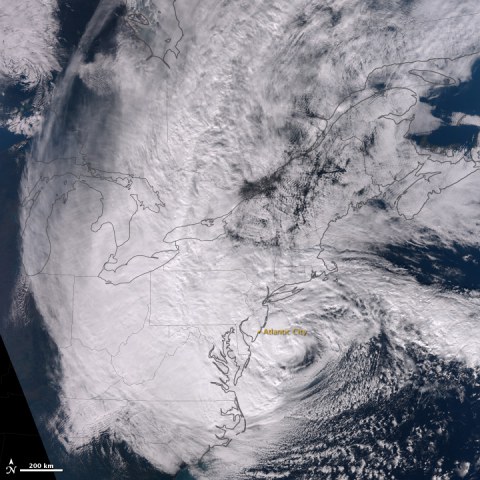
The Hurricane crossed the coast in New Jersey on Monday night, 29 October, at about 8pm not far from Atlantic City. The storm surge caused widespread flooding leaving coastal towns decimated. The winds of the hurricane caused trees to fall and whipped up a massive 3 to 4 metre storm surge. A full moon and a spring tide also exacerbated the storm surge. 10 metre waves were measured just outside New York Harbour entrance. (See Accuweather Superstorm Sandy Stats)
Related: Skeptical Science - Hurricane Sandy and the Climate Connection | Crops devastated, food crisis looms in Haiti from Hurricane Sandy | Inside Climate News: 3-D Maps Pictured Sandy's Devastation–Five Years Ago | Climate Change, Sea Level Rise and Australia
Australians can identify with this disaster remembering the impact of the Queensland floods and the flooding of Brisbane in 2011 and the death and destruction wrought by Category 4 Tropical Cyclone Yasi through Queensland. A CSIRO scientists claims while tropical cyclones may be fewer they are likely to be stronger and more intense.
The Bureau of Meteorology has produced the following table comparing Sandy to Cyclone Yasi:
| Near Landfall | Yasi | Sandy |
| Structure | Cyclone | Extra-tropical |
| Peak Mean winds | 205 km/h | 150 km/h |
| Length of coast affected by gales | 750km | 1400km |
| Length of coast affected by hurricane force winds | 130km | 350km |
| Maximum storm surge |
5.33 metres (observed / confirmed) |
3-4 metres (see article) |
Storm Surge causes major flooding and destruction
Dr Jeff Masters from the Weather Underground warned of the huge threat from storm surge as the Hurricane approached on October 28:
"the destructive potential of the storm surge was exceptionally high: 5.7 on a scale of 0 to 6. This is a higher destructive potential than any hurricane observed between 1969 - 2005, including Category 5 storms like Katrina, Rita, Wilma, Camille, and Andrew. The previous highest destructive potential for storm surge was 5.6 on a scale of 0 to 6, set during Hurricane Isabel of 2003. Sandy is now forecast to bring a near-record storm surge of 6 - 11 feet to Northern New Jersey and Long Island Sound, including the New York City Harbor. While Sandy's storm surge will be nowhere near as destructive as Katrina's, the storm surge does have the potential to cause many billions of dollars in damage if it hits near high tide at 9 pm EDT on Monday."
The storm surge was measured at about 9 feet above normal at The Battery, New York and at New Haven, Connecticut. It reached 12.5 feet above normal at Kings Point, New York. According to the US Geological Survey initial report, "Many USGS tidal sensors recorded peaks of record and several were completely overtopped. Preliminary reports include a stream height of 13.88 feet at the Raritan River near New Jersey Highway 18; 11.75 feet at Rockaway Inlet in Long Island, New York; and 11.21 feet at Raritan Bay near Keansburg, New Jersey."
The water surged into Lower Manhattan causing widespread flooding and flowing into subways and road tunnels. At least two Manhattan hospitals were forced to evacuate patients as their backup generators failed and water flooded their basements.
Meterorologist Jeff Masters called it the worst storm in the cities recorded history.
About 8 Million people have had power disrupted across 15 states, the death toll in the USA has climbed to 64 and may possibly go higher, and the damage bill is likely to exceed $20billion.
Aftermath: Superstorm causes First world Devastation
Aerial View Of Atlantic City, New Jersey Coastline After Hurricane Sandy Destruction
Aerial View of Hurricane Sandy Aftermath on Long Island - Coast Guard Surveys Hurricane Sandy
Aerial view of flooding from the storm surge in Hoboken, New Jersey
The contribution of Climate change to Hurricane Sandy
The devastation wrought by Sandy has caused climate change to be covered a little more in mainstream media with discussion over how a warming climate contributed to the power of Hurricane Sandy.
In the MSNBC show Hardball with Chris Matthews a video clip was shown of former President Bill Clinton ridiculing Mitt Romney's stance on climate change made at the Republican National Convention. This was then followed by an interview with Princeton Prof. Michael Oppenheimer who says that Climate Change 'Made Hurricane Sandy Worse'. Top Democrat Congressman Ed Markey also detailed on the show that "this frames the election for next Tuesday very well: Mother Nature versus for the Koch Brothers" as they are the single largest funders of Republicans and Mitt Romney's campaign.
Climatologist Kevin Trenbeth writing at The Conversation - Hurricane Sandy mixes super-storm conditions with climate change - described how global warming has contributed to Hurricane Sandy:
"Global climate change has contributed to the higher sea surface and ocean temperatures, and a warmer and moister atmosphere, and its effects are in the range of 5 to 10%. Natural variability and weather has provided the perhaps optimal conditions of a hurricane running into extra-tropical conditions to make for a huge intense storm, enhanced by global warming influences."
The destructive damage of storm surge and flooding will be an increasing issue as sea levels continue to rise with the rate of increase expected to accelerate as Ice sheet melting increases. "Sea level rise is a highly confident prediction of climate change research. It is clear from what we know about the climate system that the sea is now rising and this will continue and indeed accelerate into the future." said Kevin Walsh, Associate Professor of Meteorology in the School of Earth Sciences at the University of Melbourne. (The Conversation - Losing higher ground: hurricanes and sea level rise - October 31).
David Spratt outlined on the Climate Code Red blog on October 29 'Four uncontroversial facts help put Hurricane Sandy in context:' (Connecting the dots between 'Frankenstorm' and global warming as extreme weather becomes the new norm )
- The Atlantic Ocean, over which the hurricane is now travelling, is 5 degrees F (3 C) warmer than average, and warmer water increases the likelihood of stronger storms further north. September had the second highest global ocean temperatures on record.
- Global warming puts more energy into storms (Kevin Trenberth paper (PDF)). The warmer the ocean surface temperature, the more evaporation and heavier rains. [This was the case with the very heavy rains across Australia in 2010 and 2011, associated with record high sea surface temperatures across northern Australian waters at the time.] Each 1C rise in temperature on average increases atmospheric water vapour content by seven per cent. 2010 and 2011 globally (and in Australia) were the two wettest years on land on record.
- Storm surges now ride on sea levels that have risen over the last century due to global warming, amplifying flooding losses where the surge strikes. In the Northeast United States, sea levels are rising up to four times faster than the global average, making this area more vulnerable to storm surge and flooding. Multiple high tides may help drive flooding fuelled by a triple climate whammy: storm surge from a storm kept alive due to elevated sea surface temperatures; sea level rise driven by global warming; and extra heavy rains due to the extra rainfall loaded into the storm by climate change.
- There may be an Arctic sea-ice melt influence on this event, due to the stalled cold front component of the “super storm”. There is evidence connecting sea-ice loss to the more severe and extreme weather patterns in Europe and north America, consistent with research from the US National Oceanic and Atmospheric Administration (NOAA). As Arctic melting and warming destabilize the jet stream and making it more "wavy", it allows frigid air to plunge farther south. As the jet stream waves become larger, they slow down or even stall at times, leading to a significant increase in so-called blocking events, such as the current stalled cold front. These cause extreme weather simply because they lead to unusually prolonged conditions of one type or another. The recent prolonged heatwave, drought and wildfires in the USA are one example of what can happen; another is the cool, dull and extremely wet first half of summer 2012 in the UK and other parts of Eurasia.
For a rundown from a climatologist on Hurricane Sandy and Climate Change this lecture by Dr. Christian Shorey was given at the Colorado School of Mines on October 29, 2012, several hours before the superstorm hit the New Jersey coast.
Climate adaptation and emissions reduction needed
Sandy was an exception superstorm, and might be passed off as a 1 in 100 year event, but as the atmosphere continues to warm, sea surface temperatures rise, sea levels increase, the polar regions continue to warm, the hurricane season will become longer, the storms more intense. Extreme weather events are going to become more intense. Instead of a 1 in 100 year event, with a 1 metre sea level rise, stormsurge and flooding of this extent may occurr every 3 to 20 years by the end of the century. (see Lin et al. (2012))
To turn back the seas will require both major coastal adaptation strategies as well as sustained reduction in carbon emissions.
“The terrifying truth is that America faces a future full of Frankenstorms,” said Shaye Wolf, the Center for Biological Diversity climate science director in a media release. “Climate change raises sea levels and supersizes storms. The threat of killer winds and crushing storm surges will grow by the year unless we get serious about tackling greenhouse gas pollution.”
The Center for Biological Diversity are urging the Environmental Protection Agency to use the Clean Air Act to take emergency action against climate change.